Rock climbing Association for Development (RAD): satellite technology to develop new outdoor climbing routes
The Association
Founded in 2011, the Rock climbing Association for Development (R-A-D) is headquartered in Geneva, Switzerland. Its founder, Will Nazarian is a passionate globe-trotting climber with over 25 years of experience in establishing new climbing routes. RAD assists communities in Armenia, Tajikistan Lebanon, Madagascar and the United States to harness their local climbing potential. From building climbing walls to donating special gear, the organisation promotes climbing as a tool to develop other community businesses, notably in the tourism sector.
The Challenge
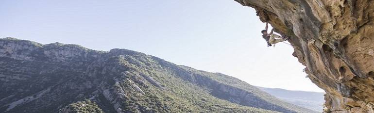
Developed during the 19th century as way to train for alpinism, rock climbing took off to become a favourite sport for outdoor lovers. A hobby that is not without risks. Remote mountains and hills are inherently dangerous places. Carrying a heavy backpack with ropes, carabineers and water, you don’t want to get lost en route. To navigate sometimes isolated areas, climbers resort to topographic maps. Maps that can, on numerous occasions, be outdated or not sufficiently accurate. Moreover, they cannot indicate a climbing route’s starting or end point, or the level of difficulty of the climb. Also, in many cases, due to their remote location, the routes do not benefit from mobile and GPS coverage.
The Satellite Solution
To map new routes, RAD teamed up with what3words, a free online GIS platform. While GPS coordinates are usually long and hard to type in, w3w uses a universal addressing system based on 3mx3m square global grid. Each of the world’s 57 trillion 3mx3m has been pre-allocated a fixed and unique three-words address. Easier to memorise and share. Thanks to a geocoder, geographic coordinates are translated into a three-word address and vice versa. Because it’s an algorithm, the satellite solution takes up less than 10 MB of space. Small enough to install on almost any mobile device.
RAD also relies on GIS applications to promote the climbs they establish. Climbing Away attracts climbers already using the site to new cliffs. The site relies on links to existing guide books so that local ownership of knowledge about the crag remains intact, while also exposing it to a wider audience.
The Result
By correctly mapping new routes, climbers’ safety has been improved. In addition, established routes help mitigate environmental impact. When people are lost, they create new trails, damaging wildlife and causing erosion. By sticking to the right trail, the surrounding land is not affected. The establishment of new climbing routes has also benefitted local businesses. In Lebanon, RAD has helped built 177 pitches in the rural village of Tannourine where nobody had thought to sport climb. Thanks to the establishment of a climbing park, the small village is slowly becoming an attractive destination for climbers around the world.
RAD constantly seeks ways to make the cliffs we develop consistent with the highest international standard of rock climbing. Only then will they be good enough to attract tourists and gain an international reputation of being a good place to visit. You can’t have people getting lost, off trail or off route. Especially in Lebanon where there are venomous snakes in the summertime and loose rocks on the steep trails. We’ve found that by using the GIS app What3Words, we’re able to accurately describe a location among the equipping teams, and by using Climbing Away we’re able to promote the cliffs regionally and internationally. The car park is packed with visitors every weekend, which speaks for itself. Will Nazarian, RAD President