Lake Neusiedl: monitoring water quality with satellite imagery
The Biological Station Neusiedler See
Lake Neusiedl, on the Austrian–Hungarian border, is the second largest steppe lake in Central Europe and a popular holiday destination in Austria. The Biological Station Neusiedler See ensures environmental protection and water quality in the area and of raising awareness on environmental issues among local communities.
The challenge
The main effects of climate change on Lake Neusiedl are an increase in water level fluctuations and eutrophication (the ecosystem’s response to the addition of substances), which also affect the lake’s reed belt and wetlands. The increase of water fluctuations could impact negatively touristic and recreational activities, while external loads occurred during the 70s caused a considerable increase in phosphorus and nitrogen concentration, with massive effects on the biological structure, such as the increase in phytoplankton biomass and the formation of blooms after 1977.
“Member States shall ensure (…) the monitoring of water status (…) to establish a coherent and comprehensive overview of water status within each river basin district” EU WATER FRAMEWORK DIRECTIVE 2000/60/EC
The satellite solution
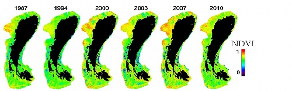
Since 2010, the Biological Station Neusiedler See has been receiving satellite images on water characteristics varying according to the temperature (as water clarity, algal biomass and class composition), which allow to assess conditions and changes of the reed area.
Such information is received within the framework of EULAKES (European Lakes Under Environmental Stressors), a European-funded project supporting local administrators to prevent and manage the impact of climate change on lakes.
The result
Satellite-derived environmental stressor maps are available to the authorities in charge of environmental protection in Lake Neusiedl area, and are used to monitor the effects of changing temperatures on the lake’s ecosystem and to assess the level of pollutants and the potential risks for the environment, people and businesses. Compared to traditional methods, satellite imagery allows for more frequent, efficient and cheaper sampling on large areas. They help monitoring changes locally and over time, since images of the same areas can be produced every few days.
“The study of ecosystems with satellite imagery provides us with useful insights into water qualitaty, supporting management of eutrophication, algae blooms and reed changes.” Thomas Zechmeister, Biological Station Lake Neusiedl
![]()