Kermap: an innovative way to monitor green areas in our cities
The company
KERMAP is a spinoff of the University of Rennes 2 and the LETG laboratory set up by the French National Centre for Scientific Research (CNRS). The company, founded in 2016, provides solutions to support cities in their ecological transition, offering a broad range of services, such as vegetation and air quality monitoring, and carbon storage estimation, among others.
The challenge
Every city is an ecosystem, and maintaining its good status is crucial for the health and happiness of city residents. This implies granting a good balance between green and built areas, sustaining biodiversity, restoring natural habitats and providing ecological corridors for wild species. The city of Rennes, where KERMAP is based, counts 12.700 trees. Among them, many are ancient specimens that need to be cut down to prevent damages to the infrastructure. To plan such works, the city needed a precise map of the trees and their species, in addition to information on air quality, infrastructure and buildings in the concerned areas.
KERMAP wanted to assist the city of Rennes in planning its tree management works. Hence, the company started looking for a viable solution to map and monitor the vegetation status. The data on green areas had to be scalable and comparable over time and be made available online to local communities, public administration, and private actors.
The satellite solution
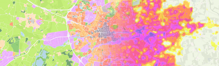
In 2017 KERMAP used satellite imagery to map and qualify green areas in Rennes. Satellite imagery reveals to be useful to map wide portions of territory in different time gaps and conditions. The images used are provided by the French Centre for Space Studies (CNES), the Bretagne province and its academic labs. The urban vegetation is monitored at least once a month to model the vegetation development cycle.
Thanks to the data collected, KERMAP prepared a demo map of the city, showing green areas and the kind of trees and plants present in different neighbourhoods, together with the percentage of vegetation compared to built-in areas. In addition to this, at the end of 2017 KERMAP realised a new demo that shows the impact of urban morphology on the local climate (KERMAP- Urban Climate of Rennes).
The users of the demo can see different local climate zones and the impacts of the urban planning on the local climate. The demo mainly shows that the urban vegetation is essential for local climate regulation. The maps are free and publicly available online, on the website of the Company (KERMAP- Green areas of Rennes). The first deliveries of the demos for the city of Rennes are expected for mid-2018.
The results
The satellite-based map will help the City of Rennes to monitor the evolution of the vegetation in different areas, the increasing of house units to the detriment of green areas and climate change issues. The map will allow city authorities to understand which trees need to be cut and to decide on where they will be replanted and on which species are more suitable for different areas of the city. The information on the vegetation cover collected through satellite imagery will also help the city to prepare its future Local Plan of Urbanism (PLU). Indeed, according to the PLU, each neighbour of the city needs to have a mandatory percentage of green areas.
Our objective is to offer a free showcase of information on the vegetation of big cities. This is possible today thanks to satellite imagery.
Antoine Lefebvre, Founder and President of KERMAP