Danube River Basin: Flood risk maps for an integrated mitigation
The Danube River Basin
The Danube is the longest river in the European Union. Originating in the German Black Forest, it crosses ten countries (Romania, Hungary, Serbia, Austria, Germany, Bulgaria, Slovakia, Croatia, Ukraine and Moldova), before flowing into the Black Sea. Its drainage basin also extends to Italy, Switzerland, the Czech Republic, Poland, Montenegro, Serbia and Bosnia and Herzegovina.
The challenge
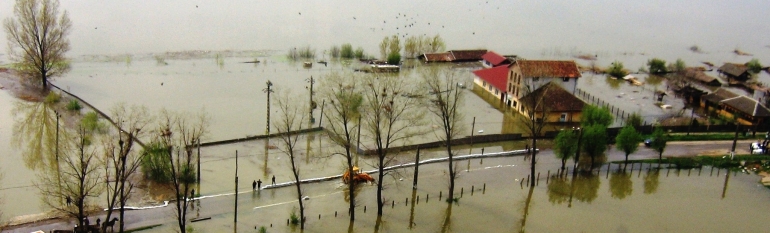
In the Danube Basin climate change-related floods are an ever greater threat to industrial activities, crops and urban settlements. In 2006 for instance, exceptionally high river levels caused considerable economic losses in Serbia, Bulgaria and Romania; numerous buildings were destroyed, leading to the evacuation of thousands of people. Danubian countries which had used until then different hydraulic models and planning systems were led to reconsider their risk prevention strategies and to look for common solutions.
“In the case of international river basin districts (…) Member States shall ensure that exchange of relevant information takes place between the competent authorities concerned”. EU Floods Directive 2007/60/EC
The satellite solution
Since 2010, under the lead of the Romanian Ministry of Environment, 24 public and research bodies from eight Danubian countries partnered to implement the EU-funded Danube Floodrisk project. After an in-depth consultation on the requirements of water managers and stakeholders, satellite imagery was combined with other sources in producing a common cartography of flood hazards and risks in the whole basin area. The carthography can be accessed on an online portal.
The flood hazard map shows extreme event scenarios, displaying the water at 1000-years return period and flood extent for 100-years return period. Furthermore? it shows potential flood damages in euro/m2 for different land use types (industry, residential areas, forestry/cultivated fields and other areas) and the number of inhabitants likely to be affected.
The result
These international flood hazard and risk map offers a more global, EU-scale overview on the Danube flood-risks than maps produced by single member states, and allows them to coordinate their mitigation efforts, according to the EU Flood Directive.. Finally, by creating the risk map jointly, each country was able to save money and resources.
“The use of satellite imagery allows us to integrate a big amount of data to assess, prevent and manage the flood risk in a common map shared among all stakeholders responsible for flood management in the Danube basin.” Mary-Jeanne Adler, Scientific Director, Romanian National Institute of Hydrology and Water Management