Hvilan Utbildning (Sweden): Enhancing learning on trees and plants with the support of satellite applications
The user
Founded in 1868, Hvilan Utbildning is the largest gardening school in Sweden, offering secondary, adult and corporate education. The School has four main premises in Åkarp, Stockholm, Järna, and Visby. The premises in Åkarp are placed on an area of 60 ha, 15 of which are occupied by buildings and gardens. Currently, 400 students are enrolled in the courses, and a large majority of them are adults.
Courses include gardening classes within the school’s facilities, as well as excursions to forests and nearby cities. Indeed, many of the students will follow a career in urban planning and tree care, and need to know which trees are most suitable for different areas within and around cities.
The challenge
In the school gardens of Hvilan Utbildning, labels frequently disappear from or harm the trees. Moreover, many of the trees are not labelled yet. Outdoor classes are carried out under the guidance of a teacher, who pinpoints to students the various tree and plant species, their names, characteristics and vulnerabilities, and how to take care of them. This means that attending classes is fundamental for students to acquire the practical skills they need.
At Hvilan Utbildning, love for nature, city parks and innovation go hand in hand. Hence, teachers were looking for effective tools to allow students to deepen their knowledge after classes, and to rapidly catch up when they missed one or more school days.
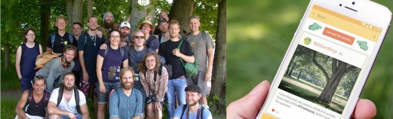
The satellite solution
In October 2016, a teacher at the nearby Swedish University of Agricultural Sciences invited the arborist students of Hvilan Utbildning to test a system allowing them to study trees and plants also without the support of a teacher. The CURIO system consists of a map based on satellite imagery allowing users to geolocate trees and to add pictures and information on them. The system is accessible through a smartphone app and a desktop platform and is conceived as an urban forestry inventory, education and outreach platform.
The feedback of the students proved crucial to improve the prototype version of the app. In February 2017, the CURIO challenge was finally launched at Hvilan Utbildning. During the summer, teachers started mapping the trees in the school gardens and in the nearby locations where learning excursions are organised.
Upon the beginning of the new semester all students were taught how to use this new tool. The tagging process is monitored by teachers, who verify the accuracy of the contents. These are available to all students, as well as to any other person subscribed to CURIO, for them to deepen their knowledge after class or to catch up on missed classes.
The results
The app has got a lot of success among students and residents in the nearby areas. Indeed, 40% of Swedish indicate gardening as their main hobby. Students and neighbours can now learn about trees that were once anonymous, about their age, characteristics and on how to take care of them, and can contribute creating a history of their urban and rural landscapes.
The system also makes available analytics based on the information collected. These will be used by the school to perform surveys in parks and to check the health status of the trees.
CURIO is currently collaborating with European city authorities to use the system as a participative tool to improve urban planning. Indeed, CURIO allows for the creation of a complete picture of urban landscapes, which is crucial for improving biodiversity, local environment and quality of life for local communities. The app is also being used worldwide and currently hosts data on over 2.1 million trees from cities across world.
The system allowing to geolocate trees on a satellite map represents a powerful tool for the students to learn about the trees autonomously”, Eric Danell, Gardening Teacher at Hvilan Utbildning, Åkarp branch.
