CNSAS: geo-information for prevention and surveillance of mountain activities
The National Alpine Cliff and Cave Rescue Corps
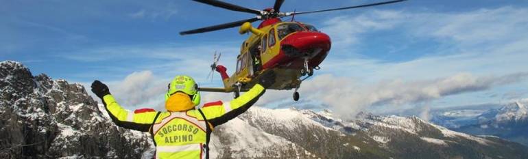
The National Alpine Cliff and Cave Rescue Corps (CNSAS) is an Italian public service, with a staff of 7,000 alpine experts, established by the Italian Alpine Club (CAI) in 1954. It is mandated by state law to rescue and help people injured in the mountains or in hostile environments. It operates from the Alps and Dolomites to the mountainous areas of the Islands. The CNSAS can also rescue injured people in caves and rock shelters, thanks to its speleological unit.
In addition, CNSAS provides assistance in case of natural disasters in cooperation with the Italian Civil Protection, the National Health Service and other regional institutions. It is also a member of the European Cave Rescue Association (ECRA), the community of European cave-rescuers.
The challenge
Climbing, hiking, trekking and other adventurous sports in the mountains can sometimes lead to serious accidents. Even an apparently small wound can seriously impair the safety of the injured person.
During mountain rescue operations, CNSAS needs extremely precise information on the position of the aid seeker and that of the rescuer. This enables the rescuers to intervene fast and carefully, while staying safe too.
The satellite solution
After an emergency call, rescue operations begin. On the ground, the Search Team members are equipped with satellite navigation devices and radio systems that send their location in real time to the central command. They can be used alternatively according to signal availability, without losing contact and control. At central level, the coordinating team visualises the position and movement of the team members on a geo-information system relying on satellite cartography, 3D pictures and aerial images of the landscape.
Finally, outdoor sports practitioners can download GeoResq, a smartphone application developed by CNSAS. This app enables the users to track their itinerary, to be constantly geo-located and to send a help request to the central command 24/24 hours. This combined geo-information allows the rescue team to take the safest routes to the victims. Central command can even advise recovery aircrafts on how to avoid potential obstacles and on weather conditions.
The recording of satellite data during the rescue plays an important role both for security and legal reasons because in case of an unpredictable accident there are legal evidences of how the operations have been carried out.
The results
Thanks to these combined technologies and to geo-information, CNSAS can intervene fast and effectively, both in minor cases (lost tourists), and in major catastrophes.
For instance, in August 2014, two Italian Air Force Tornado aircrafts crashed into a mountain. Using satellite navigation systems, 200 CNSAS’s Research Specialists coming from six different Italian regions helped out in the finding of four crew members’ bodies and two black boxes. Thanks to satellite information, it has also been possible to identify numerous fragments of the two aircrafts.
CNSAS’s support is sometimes solicited in different countries. For example, when a German speleologist in Bavaria fell 1,000 meters deep, the German authorities asked CNSAS to intervene. It took 15 days of work supported by high-technologies, including satellite-based tools, to save him.
Nowadays, satellite navigation systems are fundamental for an efficient and effective mission, allowing time savings and extreme accuracy during rescue operations. Walter Milan, National Alpine Cliff and Cave Rescue Corps Press Office
![]()