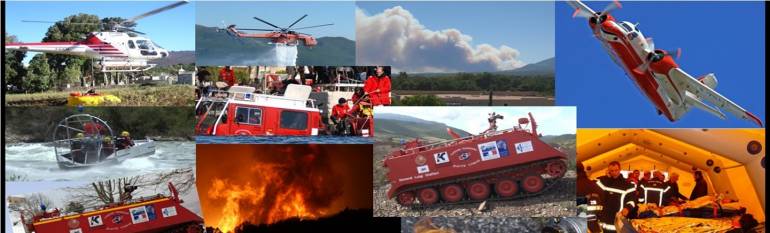
In Haute-Corse, rescue and fire units use satellite information for real-time tactic situation management
The organisation
The Haute-Corse departmental service for rescue and fire (SDIS 2B) is based in Furiani in the North of the French Island. It employs 1200 firemen to insure the protection of people, goods and the environment. SDIS 2B is in charge of risk assessment and evaluation, managing all rescue resources, and intervening in case of emergency.
The challenge
Haute-Corse County is highly vulnerable to natural hazards, especially forest fires, being a mountainous area with a dry climate. On average, 1750 forest hectares burn and 800 forest fires break out every year in Haute-Corse. In carrying out prevention, protection and rescue missions, SDIS 2B must be able to know with an extremely high accuracy and on time what the situation is on the field (the state of the vegetation, the position of its intervention units, thin weather data, among others). The SDIS needs the relevant info on time, to be able to evaluate the stakes, fix the objectives and optimise the operational reply.
The satellite solution
Since 2005, SDIS 2B uses a 3D map visualisation service that combines aerial and satellite-derived maps, real-time aerial videos (such as a Canadair dropping on zone), as well as weather data, to give a complete picture of risk situation for both forecast and operational management.
In addition, the mapping service integrates the geo-information gathered in the operational GIS of the SDIS, enabling the management team to know the position of the rescue units and equipments via GPS receivers, in real time.
The result
Thanks to the mapping service SDIS 2B knows the situation on the ground in real-time and with more accuracy, whether for preparedness measures or intervention. It is thus easier to monitor the soils modifications (urban sprawl, burned area, vegetation cover) and to assess risks and various stakes. With such accurate information, SDIS 2B optimises the commitment and deployment of fire fighting and emergency means in a safe manner.
Finally the use of a unique 3D mapping tool lightens working processes and supports inter-services collaboration through a better information sharing.
We use satellite applications every day. They have become essential tools in the conduct of our missions, both provisional and operational. Marien Setti, head of the SDIS 2B operation group