What is precision agriculture? Watch a couple of videos below to learn more.
Video by Satellite Applications Catapult.
Below, a driverless tractor in the Netherlands (more on the website of the University of Wageningen here):
Share this video
Example of the use of satellite and GIS technologies for agricultural water management in Marchfeld, Austria
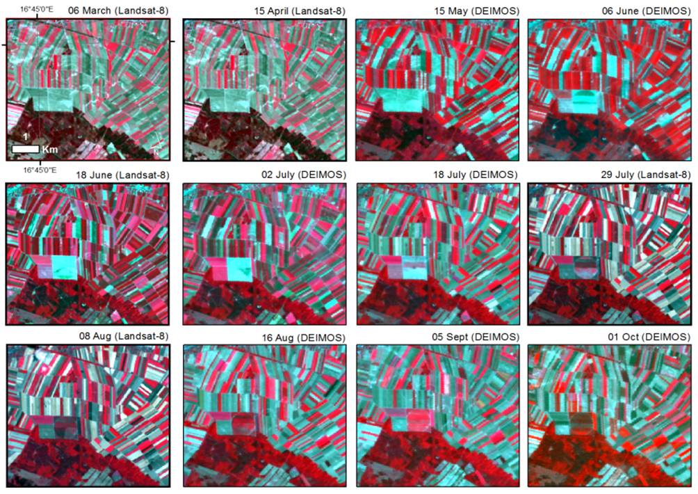
The figure shows a near-infrared colour composite of a time series of DEIMOS-1 and Landsat-8 satellite images over Marchfeld (Lat. 48.20°N, Long. 16.72°E), a semi-arid agricultural production area in Lower Austria with more than 60,000 ha of agricultural land cropped with vegetables, sugarbeet, potatoes and (winter and summer) cereals. Here, the average annual precipitation is 500–550 mm that can drop to 300 mm making it the driest region of Austria. Groundwater is used for irrigation and also as a major source of drinking water. Correct irrigation, soil and nutrient management are important to guarantee conservation of resources, to reduce excess runoff and mobilization of nitrates.
The adoption of innovative tools in the area is stimulated by an increased ecological awareness among consumers. These consumers research local, high-quality and fresh food, and like to be informed on how it is produced and whether the water footprint in the various production steps is sustainable. In this context, farmers are very interested in testing innovative solutions to improve the efficiency of irrigation. Indeed, this results in a better use of water resources and cost savings (irrigation fees, equipment runtime, energy required for pumping and fertilizer consumption).
Advancements in a variety of technologies for precision farming are taking place. Among these, remote sensing techniques have been implemented since 2012 to support irrigation management funded by the Austrian Research Promotion Agency (FFG). Satellite images and maps are integrated in a dedicated geographic information system that translates the information into an easy- and ready-to-use irrigation advice delivered directly to the farmers. Ongoing developments and experimental research include the use of satellite and ground sensor data for nutrient management and quantification of crop production.